Map - Baruta (Municipio Baruta)

Baruta (Municipio Baruta)
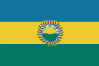
Baruta (pop. 317,288) is a municipality within the Metropolitan District of Caracas in Venezuela.

Baruta is located geographically in the South-East section of the city. Its western limit is the Los Chaguaramos neighborhood (which belongs to the Libertador Bolivarian Municipality) and limits to the east with the Colinas de Los Ruices neighborhood, in the Sucre Municipality. To the North, it borders with the Francisco Fajardo Highway and to the Southeast with the El Hatillo Municipality and to the Southwest with the Hoyo de la Puerta neighborhood (Libertador Municipality).

 
Map - Baruta (Municipio Baruta)
Map
Google - Map - Baruta
Google
Google Earth - Map - Baruta
Google Earth
Nokia - Map - Baruta
Nokia
Openstreetmap - Map - Baruta
Openstreetmap
Map - Baruta - Esri.WorldImagery
Esri.WorldImagery
Map - Baruta - Esri.WorldStreetMap
Esri.WorldStreetMap
Map - Baruta - OpenStreetMap.Mapnik
OpenStreetMap.Mapnik
Map - Baruta - OpenStreetMap.HOT
OpenStreetMap.HOT
Map - Baruta - OpenTopoMap
OpenTopoMap
Map - Baruta - CartoDB.Positron
CartoDB.Positron
Map - Baruta - CartoDB.Voyager
CartoDB.Voyager
Map - Baruta - OpenMapSurfer.Roads
OpenMapSurfer.Roads
Map - Baruta - Esri.WorldTopoMap
Esri.WorldTopoMap
Map - Baruta - Stamen.TonerLite
Stamen.TonerLite
Country - Venezuela
Currency / Language  
ISO Currency Symbol Significant figures
VES Venezuelan bolívar BsS. or Bs. 2
ISO Language
ES Spanish language
Neighbourhood - Country  
  •  Brazil 
  •  Colombia 
  •  Guyana 
Administrative Subdivision
City, Village,...